

St. Croix Summer Paddle: Hwy 70 to Sunrise River

The water grew louder and from a distance we could see small whitecaps. As we got closer, riffles and small rapids danced throughout the width of the river and we shot for the smoothest section or small V’s that indicated a clean line. As we bounced along, the river sang her song and then quieter waters came.
This 18 section could be called the riffle route as numerous riffles and small rapids dot the river for the majority of the distance. Pockets of slow currents flow in between. Follow along as we share our tips, maps and resources that will get you exploring next weekend. Here you go.

Photo: edlundphotography.com
Our Backyard River
The St. Croix River flows lazily within walking distance of our home. Every year we try to explore a little more of it. Roughly 160 miles in length, it begins its journey at Upper St. Croix Lake in northern Wisconsin and eventually joins with the waters of the Mississippi flowing to the gulf of Mexico. It is a designated wild and scenic river, protected by the National Park Service. Its long history begins with evidence of human occupation 10,000 years ago and follows the lives and ancestral lands of the Ojibwe people. Beginning around the 1600's, it was a favored fur trade route which eventually gave way to logging and early European settlers in the 1800’s.
Its banks are lined with birch, aspen, basswood and maple with pockets of white pine and spruce; evidence of a northern hardwoods forest. Numerous backwaters and woods are home to a variety of waterfowl as well as beaver, muskrat, otters, black bear and whitetail deer.


Photo: edlundphotography.com
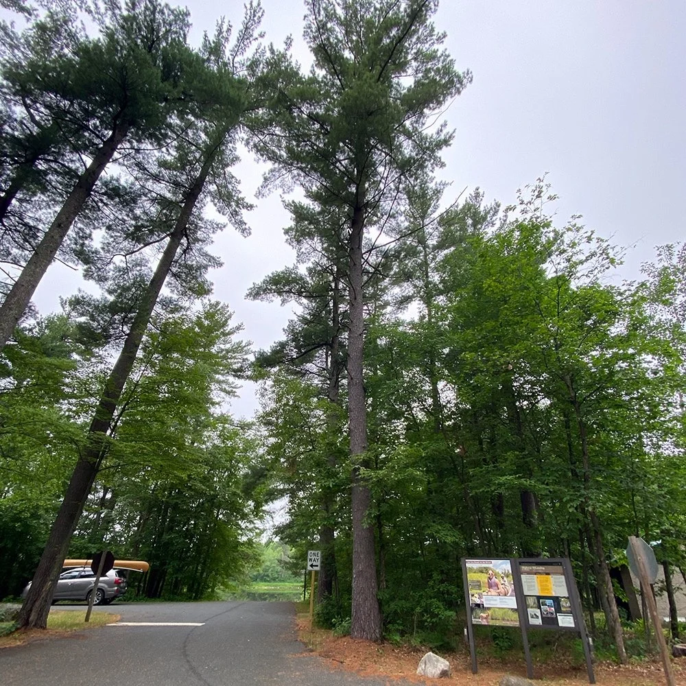
Putting in at Hwy 70 Landing
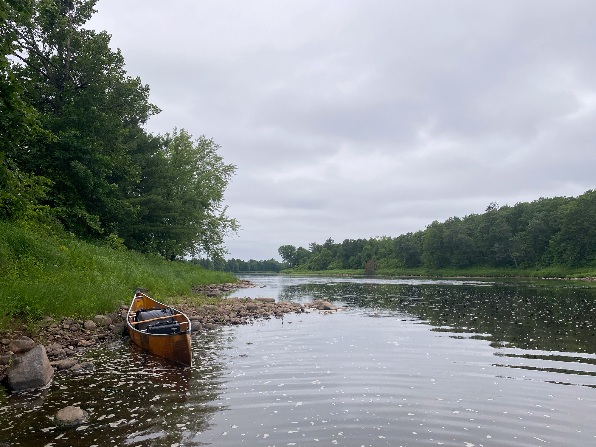
Tall white pines filled the landing parking lot - a welcoming sight. The lot was empty, save for one car and it helped that we were paddling on a weekday. We figured it was a sign of things to come and that we might have the river mostly to ourselves. The canoe was set along the bank as food, water and gear was sorted. Dipping our paddles, there was no breeze as we cut the reflection of clouds and trees. Almost right away was our first set of riffles. Maybe they could be called rapids, but they were pretty small. Due to lower water levels, we were careful not to hit barely submerged boulders. This would be the pattern throughout the day as we headed south.
Many sections of the river were fairly shallow and we had to course correct a few times to avoid becoming beached. As the current moved along we saw very few small homes or cabins. It was a classic summer day - warm and humid. Every hour or so we stopped at one of the sand bars along the river and took a break, grabbing a water, snack and letting the dog cool off. We spotted larger birds, such as the great blue heron, a golden eagle and bald eagles. Throughout the day, as the sun started to shine, partially submerged logs held painted turtles and small shore birds. Occasionally a kingfisher would pop out, calling a warning to others that we were passing. In the early afternoon we paused for a shore lunch as the campsites were buggy. It was a great, sandy spot to take a few dips and sit for a spell, enjoying the small riffles nearby while noshing on smoked brisket and potato salad.
As we made our way with the current, we saw a total of about four fishing boats. Clearly, mid-week is the time to go for solitude. Songbirds and frogs serenaded us onward. We continued to take breaks to cool off. In one area we saw a half-dozen young deer or fawns quietly grazing along the shore. Creeks and springs flowed in along numerous points, chuckling into the river. Shells littered the banks - evidence of the river otter. There was plenty of time for us to float along and relax or take pictures.
Campsites along the way were quiet and varied with some tucked further inland and others more exposed. They all are identified by brown National Park Service signs. Each sign usually notes the river mile, helping making identify our location pretty easy. Most sites have a picnic table, fire ring and pit toilet. They’re all available on a first come, first served basis. We could plan on a multi-day trip along the river at some point. Fall paddling would be gorgeous.


Finish at Sunrise River Landing
Towards early evening, the current slowed and became deeper as we rounded the few last bends. We spotted our landing, river right, where we had parked a car at earlier in the morning. Our trip had taken about 6.5 hours with stops, not including car shuttling. Knowing the bugs would be bad, we drove the car down to the landing and hurriedly packed up, while donating quite a bit of blood to the local mosquito population. As the car wove down the lonely forest road, we reflected on our journey. Shoulders felt a little sore, our skin was pink from the sun and our smiles were wide - hearts full to the brim from the joy of being on the river.
Rocks along the shoreline and the river made for careful navigation.
GOOD TO KNOW
Check out a Google map of our route of our route which includes points of interest.
The National Park Service has great maps of all sections of the river.
River navigation is not overly hard, but you should have a printed map and a map downloaded to your phone. The easiest way to navigate is to keep an eye out for campsites which are clearly marked with small, brown signs along the river bank.
There are small riffles and rapids in this section. Pay attention as there will be better “chutes” to paddle through indicated by small downstream V’s in the river or less disturbed water. None of the rapids were hard, but we were choosey in where we paddled with our kevlar canoe.
The river flows at about 3-4 mph. We paddled it in early July.
This section had many visible boulders above the surface as well as boulders just hidden under the surface. Keep an eye out for disturbances in the water indicating a possible obstacle.
The river is full of channels, some passible, some impassible, so keep an eye out for those.
There are outfitters who offer boat rental and shuttle service along some parts of the river. We drove two cars and left one at Sunrise River Landing since there isn’t a shuttle service along this section.
Hwy 70 Landing has a large parking lot, including spaces for trailered boats, a pit toilet and informative maps. It’s a steep slope down the landing to the river .
Please plan for the conditions you may encounter. Sometimes it’s hot, buggy, windy or cool. Bring plenty of water (we recommend 1 gallon per person) and food or snacks. Bring along a small first aid kit, extra towels and gear for starting and putting out a fire. Be a good human and pack out all of your garbage or garbage you come across.
Disclaimer: Some of the information mentioned may or may not be accurate or up to date. It’s your responsibility to check local resources for river updates, conditions and closures. Difficulty will depend on the season, water levels, weather, your experience, skills and fitness level.