

Bikepacking the Monster Gravel Loop
Spring thunderstorms threatened as we biked down the gravel trail towards the little town of Siren. Coincidence? Maybe not.
Bruised clouds made a foreboding line to the west. It was a contrast to the bright green of early May. We could see rain and wondered how long it might take us to get 5 miles to town where we could seek shelter. Then a small tunnel appeared. One of a few along the Gandy Dancer Trail system in northern Wisconsin.
My first ever bike packing adventure kinda began as a last minute whim. Most of my adventures are planned months in advance, with careful preparations and training. Not with this one. I winged it this time!
A call to ride.
It began when my friend called and said, “hey, want to bike the Monster Gravel loop with me in a couple of weeks? It’s 100 miles.” I’d never heard of it. I didn’t even know where it was. I don’t do a ton of biking these days and this would be the first time on my bike this year. Totally not recommended, but whatevs.
I was intrigued, but communicated that I was a total newbie to this sort of thing and hadn’t event dusted off my old, seen-better-days bike. I wasn’t even sure that I could bike 50 miles two days in a row. I didn’t even know how to use those pannier thingy’s. Hoping to avoid a complete sufferfest, I thought maybe I could pull of 50-70 miles total. Maybe. So, I told her sure but that I’d ask my husband to be on stand-by to pick me up as soon as the wheels fell off, so to speak. Biking friends came together as someone offered me the use of their bike and another person offered me bike packs. I didn’t need panniers after all.


Sunshine and storms.
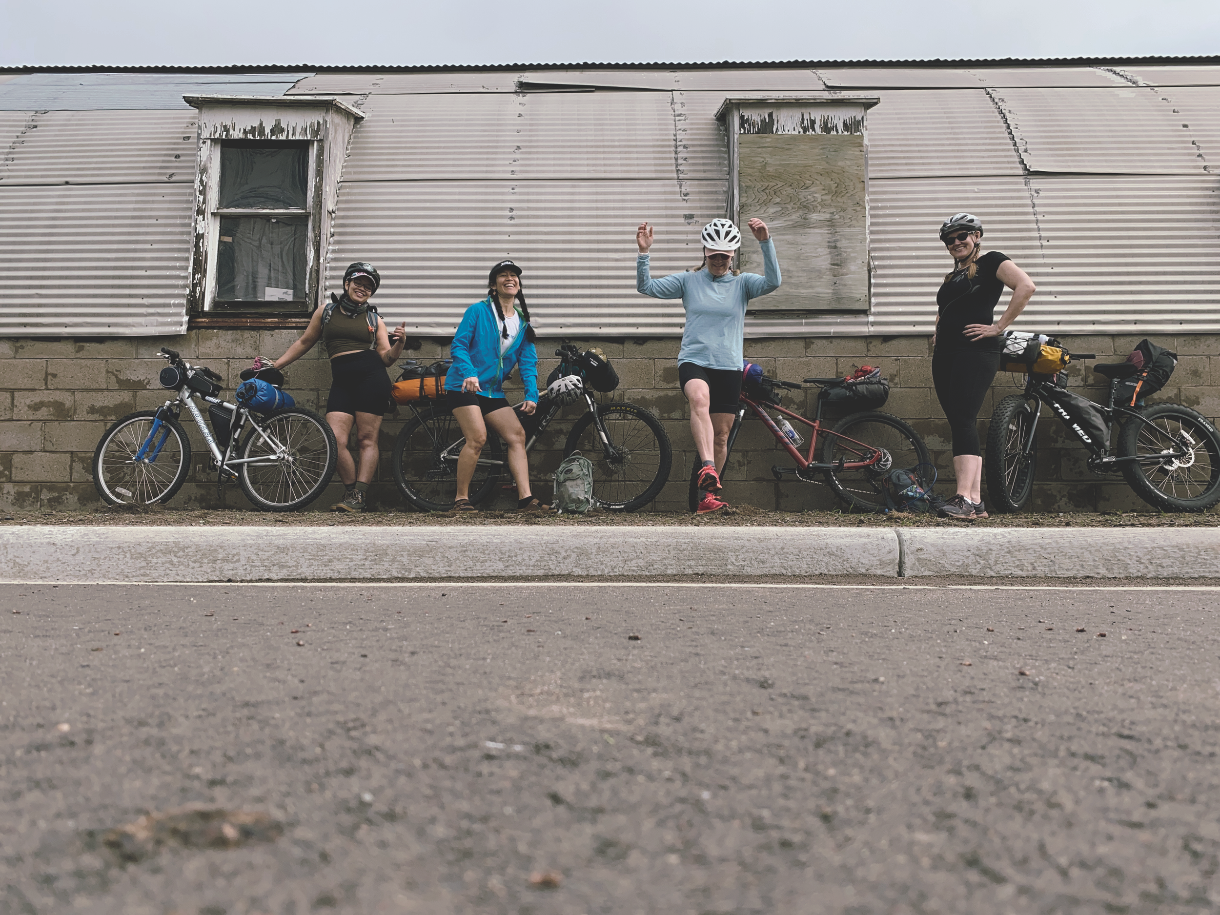
Four of us met up and started from Milltown, a quiet farming community in western Wisconsin. There is a community center there that gave us permission to park our vehicle. We also called the police to let them know a car would be left there overnight. The Gandy Dancer trail was accessible about a quarter mile to the east. After strapping on our packs we set out at 9am. I was nervous and wondered how long my body would hold up.
The Gandy Dancer trail is a former rail bed and has been redesigned as a multi-use gravel trail. Flat and even, it travels through farmlands of corn and soybean, hummocky woods filled with birch and white pine as well as wetlands teeming with waterfowl and frogs. It’s an easy trail to follow and at the beginning of our route, skirted through and around quaint towns every 5-7 miles. As a result, I didn’t carry much food knowing we’d stop a few times at restaurants and have access to gas stations or grocery stores just off-trail.
Our first stop was at Cafe Wren for lunch, just 5 miles past Milltown. This charming cafe has excellent, locally-made fresh food and coffee. We enjoyed the gentle breeze on the patio.
Bellies filled, we continued northwest, pausing through the towns of Frederic, Lewis and Siren. We biked past bubbling creeks and thick woods filled with brightly colored songbirds flitting amongst the trees. The temperature was expected to be near 90º, however overcast skies and a breeze made it feel more like 80. During the afternoon, clouds became darker to the west. We paused and checked the radar on our phones. There was a strong line of red headed our way. We hoped to make it 5 miles to the next town but a short tunnel appeared first. Figuring we couldn’t out bike the curtain of rain, we ducked under it and waited for the worst of it to past. The clouds petered out as we pushed further north. The sun began to appear, allowing the heat to build.


Wisconsin food pyramid; burgers, beer and cheese.
When we got to Siren, we had done 20.9 miles and we were feeling hungry. A few blocks off trail was the Pheasant Inn and Sports Bar. We tucked our bikes out of sight alongside the building. A good ‘ol cheese-laden Wisconsin burger and fries followed. Someone played the slots in the corner and a few were gathered around the bar, but it was cool and quaint. And it had flush toilets. The perfect place to bring our stinky selves.
As we wrapped up dinner, daylight was waning and we knew we wouldn’t be completing 50 miles. By our calculation, it was likely going to take at least 5 hours to cover 30 more miles; a challenge our group wasn’t presently up for. At the restaurant, I started googled other camping options - both dispersed and reservable within a 12 mile radius. I found a handful of resorts but after a few calls, found that they were only open to RV campers. Digging some more I read about the Burnett County Forest and checked land usage and found that dispersed camping was allowed. Yay! But, we’d need to jump through some hoops to reserve a camping permit. Not super easy, but not impossible. So, that became our Plan B. It was 15-18 miles away, depending on where we’d find camping in the forest. None of us had ever been that way we didn’t know what to expect. Part of the challenge of doing our route was that it was the first time three of us had done it. One person had biked the section we had just done along the GD, but didn’t know the route beyond that. I was happy that in most places we had good cell service.
Daylight is burning.
So, as the sun was setting in the west, we cycled out of Siren. The group moved slowly. A few miles and nearly an hour later, I began to feel that we should probably discuss another plan. Calculating our pace, I knew we wouldn’t likely reach the county forest before 9pm. We all knew that there was a high threat of thunderstorms that night. It was important we had a safe, dry space to camp and properly set up our tents for the coming storms. The group stopped to reassess. One person found that there was a motel in Webster, just 3 miles away that we could go to. It seemed like the best choice and would allow us to be done biking by around 8pm. The other option was to stealth camp and outside of a slough, it looked like private property for miles.
We got to Webster and found that unfortunately, the motel had closed. So, what to do? It was nearly 7:30pm. Webster is a very small town, smaller than the one’s we’d been through so we searched our phones for options. We found the only airbnb in the area and kindly asked the owner to let us stay there - even if it was on the lawn (initially she said no as it wasn’t ready). She asked us to wait about an hour, so we grabbed ice cream. Cooled off, we biked to the cabin, located a quarter mile off the Gandy Dancer. Very convenient! Finally, nearing, 9pm, we dropped our packs, took a shower and relaxed. Everyone was in good spirits despite the long day. It was nice being sheltered as heavy thunderstorms came through during the night.


Solo forward.
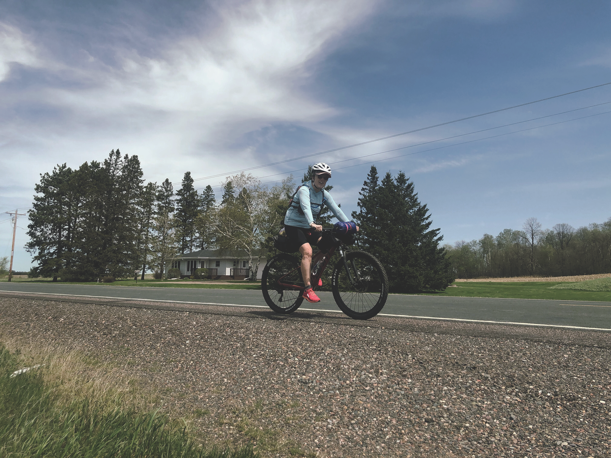
The next day dawn bright and was going to be in the mid-70’s. Pretty perfect. Because I had obligations back home, I opted to get up and leave by myself at 8:30am. Instead of returning the way we came, I continued on the intended route, headed west, away from the Gandy Dancer. I hoped to do 25-30 miles and eventually meet my partner somewhere south, towards Grantsburg by 1pm. The route followed empty paved and gravel roads through remote state natural areas and forests. Until Grantsburg, I saw two cars that day. Initially, the route was dotted by private land with small cabins, mobile homes and the random hunting shack. The trees were bright green with buds starting to burst. Water flowed and filled the drainage ditches and settled in large puddles on fields. It was cool and it felt amazing with the sun on my back. My bottom hurt, but I had solved some of the pain by wrapping my rain jacket around the seat. I enjoyed the solitude as I biked past floweages filled with waterfowl and frogs. The tread was good and elevation relatively flat. Occasionally, I’d pull over and enjoy a handful of trailmix, taking in the views, listening to morning sounds. Blue Dwarf and Mourning Cloak butterflies zig-zagged about the bike - bright spots of blue, yellow and brown.
As the morning got later, I split from the original route and made up my own way southwesterly, towards Grantsburg. I cobbled together country roads, hopping through a couple of quiet construction sites as the scenery changed from woods and wetlands to farmland. Looking at my pace, I knew I’d make it past Granstburg. So told my partner, who was working in St Croix Falls, to come find me somewhere along 87 (a quieter hwy headed south). Hugging the shoulder, I pushed out of Grantsburg into a strong headwind. I’d enountered headwinds all way, but they were bufffeted some by the trees. Now the open farmland protected me from none of the gusts. It was very slow going. But forward progress, is progress and I was excited to see a familiar face and get off my sore seat. About 5 miles south of town, he came into view and pulled over at the Grettum Flowage. Thirty miles later and just after 12:30, I had done it! I had bike 62 miles over two days. Whew.


What I learned.
I didn’t look at the route much ahead of time; something I normally do and wished I had done. I would have looked at trail town services along with lodging/camping along the way. I think too, that it’s important to choose a route based on the collective experience of the group. Until I showed up at Milltown, I only knew my friend who planned it. Everyone was really kind and I enjoyed getting to know the others, but I had no idea of how well we’d ride as a group. It might have been nice to do the planned 50 miles each day, but in the end, it wasn’t very realistic. As a result, we didn’t have a plan B in place. We figured it out, but I felt stressed about not having done more research regarding route and camping conditions ahead. It’s a good reminder to look over the details before committing to plans.
I also learned that while I enjoyed bike packing, I still prefer back packing. Maybe if I had a bike sized for me and a more comfortable seat, I’d be more into it. Ugh, my sore seat! I did like the similarity to backpacking where you’re exploring new trails self-propelled.
Other than that, I felt really good and wasn’t very sore elsewhere. I was happy with what I ate and packed. More on that below.

The bike set up.
I used a Giant brand bike, borrowed from a friend. Over all, I appreciated the opportunity to use it for the trip. It helped me figure what I do and don’t like in a bike set up. If I were to get into bike backing seriously, I’d likely change up the handle bars too. It preformed excellent on all the surfaces I encountered.
My son is a bike mechanic at Chilkoot Cyclery in Minnesota, and although the bike is pretty new, I had him take a once over to make sure it was rider-ready.
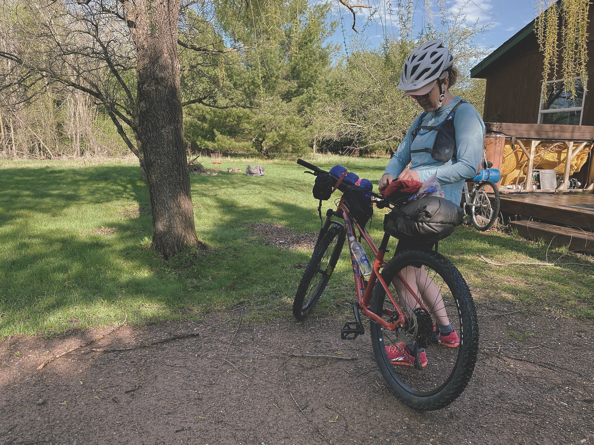
The seat pack held a sleeping pad, sleeping quilt, headlamp, toiletries, rain jacket, small bag of food, pair of shorts and one t-shirt. I strapped my tent to the bike handles. Two carry all bags strapped to the bars held first aid, snacks and sun block. The tube bag held my iphone, charging brick and cords. The day pack held more snacks, water, cash and ID, as well as my bathroom kit (kula cloth, hand wipes, hand sani and bidet). I had a 24oz Smartwater bottle inside a cage that connects to my Saywer filter and also provides another way to carry more water. Thank you to my generous friends who borrowed me gear and help me get set up for this adventure! You all rock.
Head out on your own Monster Gravel Loop ride and follow my online resource for creating a great adventure. It includes a maps and packing list too!
Disclaimer: Some of the information provided in this article may not be current or accurate. Conditions along this route are subject to change based on seasonal changes or road work. It is your responsibility to plan for, train and prepare for your adventure. Plan for the conditions you might encounter. Spring in northern Wisconsin is variable, so have a good handle on the expected forecast. Cell service is pretty good in most areas, but not guaranteed. Emergency services in small towns are sometimes staffed by volunteers and help may be hours away.