

St. Croix Summer Paddle: Sunrise Ferry to Lion’s Park
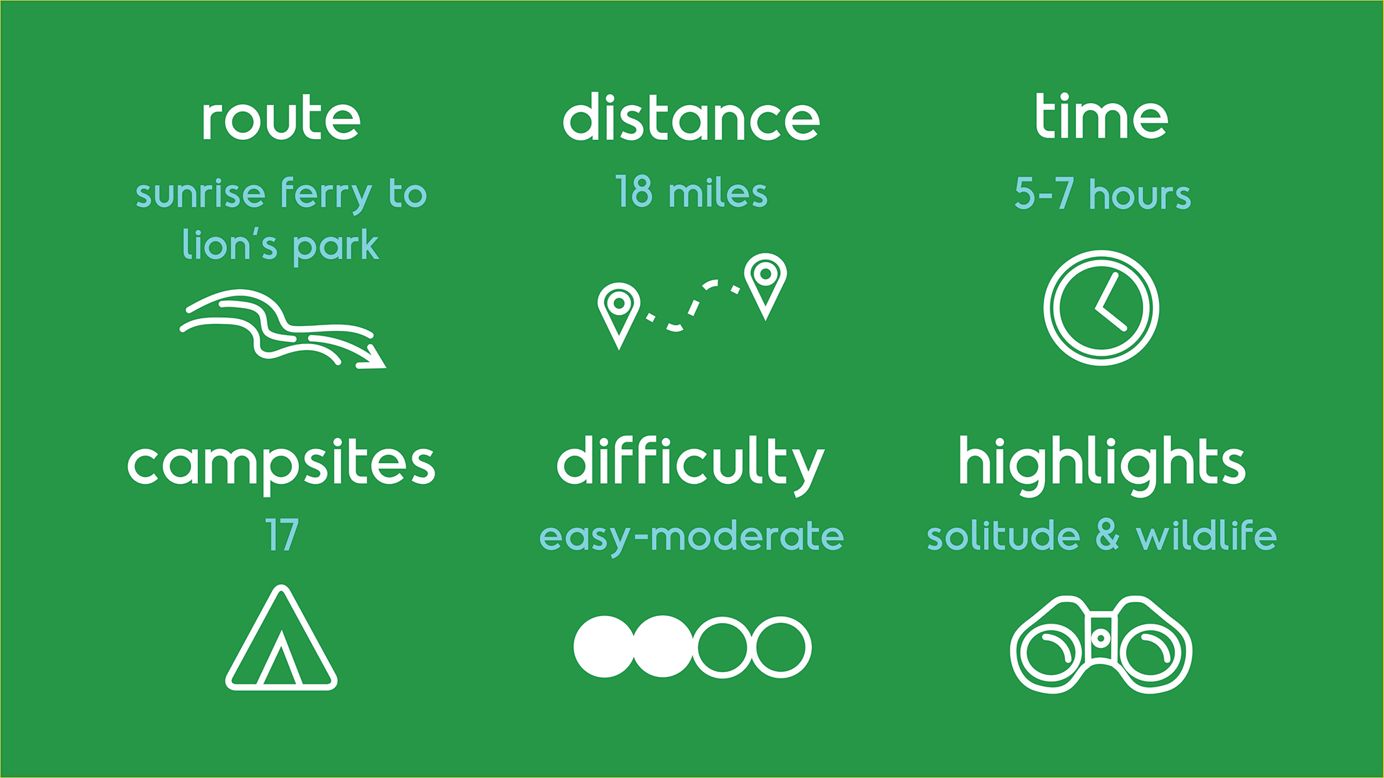
Scanning the river we saw nobody; just miles of green hardwood forest extending as far south as we could see. The St. Croix River, green and flowing with possibilities. We pushed the canoe into the current, the dog and a cooler snug in their places. Settling in we pointed the bow towards St. Croix Falls, Wisconsin, roughly 18 miles to the south.
A full day of sunshine and sky-blue waters to enjoy on a section that we hadn’t explored before though we live near this great, national scenic waterway.

Our Backyard River
The St. Croix River flows lazily within walking distance of our home. Every year we try to explore a little more of it. Roughly 160 miles in length, it beings it’s journey at Upper St. Croix Lake in northern Wisconsin and eventually joins with the waters of the Mississippi flowing to the gulf of Mexico. It is a designated wild and scenic river protected by the National Park Service. It’s long history begins with evidence of human occupation 10,000 years ago and follows the lives and ansestrial lands of the Ojibwe people. Beginning around the 1600'’s it, was a favored fur-trader route which eventually gave way to logging and early European settlers in the 1800’s.
It’s banks are lined with birch, aspen, basswood and maple with pockets of white pine and spruce; evidence of a northern hardwoods forest. Numerous backwaters and woods are home to a variety of waterfowl, including beaver, muskrat, otters, black bear and whitetail deer.
Starting at Sunrise Ferry Landing
Knowing the day was expected to have great weather, we looked at the national park service maps of the riverway and choose a section about 1.5 hrs north of us. Loading up food, water, some basic emergency gear, first aid, sunblock and our brown pup, we strapped our canoe to the car and drove north. For ease of our route choice, we decided to drive two cars and dropped one off first at our take out point at Lion’s Park in St. Croix Falls. From there it was a 40 minute drive to Sunshine Ferry Landing (the last few miles of the route is on gravel roads).
We parked at Sunrise Ferry Landing, greeted by a million mosquitos. The landing is just a small parking area with no amenities, so we made quick work of unloading our gear and getting onto the water where a gentle breeze blew away the bugs.


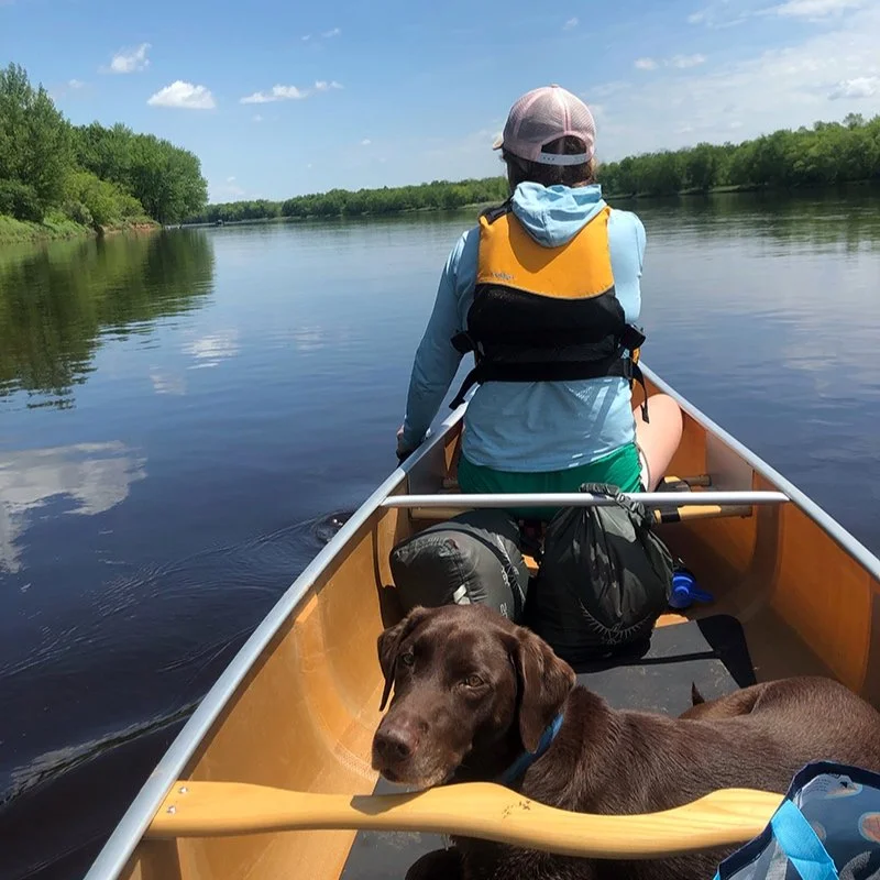
Sounds of birdsong and water gently hitting the bow filled our ears. Not a house or boat in sight. For many miles we had the waterway to our selves. Even though just a couple hours from a major city, it felt wild and remote. We followed close to the erroded and sandy banks, as painted turtles sunned themselves on downed trees. Birds dipped and sprung between oaks, basswood, maple and ash trees. Hackberry and honeysuckle bloomed in pockets. We passed islands, occasionally pausing to get out, let the dog swim and run while stretching our legs. Some of these would make great spots to hang out on with more time.
Campfire Lunch
There are designated campsites along the river, open to everyone on a first come, first serve basis. They all have picnic tables, a fire ring and a latrine. They vary in size, but the ones we saw would probably fit 2-4 tents and/or a couple of hammocks. Stopping at a western facing site in the afternoon, we gathered dry wood and made a fire, enjoying a family of geese and their goslings float by. The breeze kept most of the mosquitos away and we enjoyed Chicago-style hotdogs under the shade of a few oaks. It was a nice site would be a great option for an overnight trip.

First come, first served campsite along the river. There are 14 campsites between Sunrise Ferry and Lion’s Park boat landings.


Shallow waters and few people
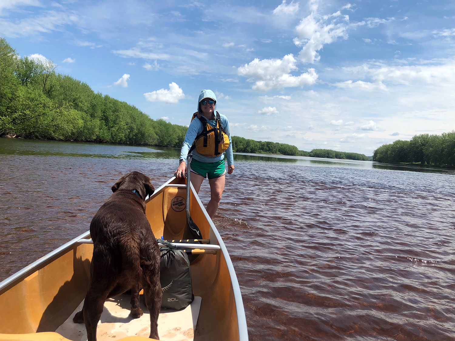
As we continued south, few small fishing boats passed us, but otherwise we saw very few other people (just some hikers on land). Around Never’s Dam Landing we saw what appeared to be old rock pylons from logging days. Further along, great blue herons and kingfishers sat on branches and scouted the banks for small minnows flying barely head of the canoe. The river was easy to paddle and in some areas was only about a foot deep with clear and sandy bottom. At one point it was so shallow we got out and floated the canoe, enjoying the cool water on our feet. It made us curious how the river moves and shifts as we’ve encountered shallow sections before.
Very shallow section of the river where a short pull was required. Can you see the dark edge where it gets deeper again?


Finish at Lion’s Park Landing
The breeze continued throughout the day, keeping us cool under full sunshine. Vehicle traffic was noticable further south as River Road followed very closely, but not really in view of the river. Periodically, we stopped and got out on one of the many sandbars along the river, stretching our legs, letting the dog run, identifying birds and animal tracks.. We still didn’t see any houses until the take-out point, a highlight of this long stretch.
About five and a half hours later, Lion’s Park landing came into view, obvious along the river bank and well marked. A small city park, it has a number of amenities including a nice dock, large parking lot, bathrooms and drinking water. A perfect microadventure near home and dreams of exploring more parts of the river this summer.
PLAN YOUR OWN ADVENTURE
Here’s our handy tips and resources for creating a fun and safe experience!
We paddled a section north of St. Croix Falls, Wisconsin and printed out this helpful map of our route. There were maps at the Sunrise Ferry boat landing as well. We calculated the distance we wanted to paddle using the mile markers indicated on the NPS map. All campsites have brown signs and are usually numbered, making identifying your location easy.
Another map of of our route we created in google maps with campsite lunch location and points of interest.
The St. Croix River generally flows at 4mph allowing you to travel quite a few miles with easy paddling. While there sometimes can be pushy or unpredictable undercurrents, we found the paddling easy and straightforward with only one very small section of riffles. Check the park website for closers and current conditions. Floating logs or other natural debris is common in the river.
There are no fees to park at boat landings or campsites along the river. A maximum 3 night stay is allowed at a campsite. Some boat landings have numerous amenities like bathrooms, drinking water and ample parking, while others are small with just a boat landing.
There are canoe and kayak rental services and shuttles along the river that offer various distances and locations of trips. Even on a beautiful Sunday we only saw one other canoe.
Watch the forecast as the wind can pick up unexpectedly and make paddling challenging.
We consider this and easy-moderate paddle. It’s a long distance, but if you have time, you don’t have to paddle hard.
Please wear a life jacket regardless of your swimming skills, water temps or the expected forecast. Deaths occur on the river every year.
Be an awesome human and help care for the river by leaving no trace and taking home your garbage (and garbage you come across).

Looking back north along the line of endless green. Gorgeous!
Disclaimer: Some of the information mentioned may or may not be accurate or up to date. It’s your responsibility to check local resources for river updates, conditions and closures. The St. Croix National Riverway Center in St. Croix Falls is a good place to start. Difficulty will depend on your experience, skills and fitness level.